


LAKE TWP LATCHA Voting District, Wood County, Ohio
About
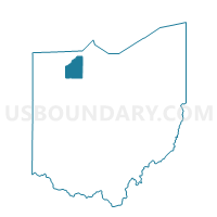
Outline

Summary
| Unique Area Identifier | 653347 |
| Name | LAKE TWP LATCHA Voting District |
| County | Wood County |
| State | Ohio |
| Area (square miles) | 18.07 |
| Land Area (square miles) | 17.98 |
| Water Area (square miles) | 0.09 |
| % of Land Area | 99.52 |
| % of Water Area | 0.48 |
| Latitude of the Internal Point | 41.53396840 |
| Longtitude of the Internal Point | -83.47475090 |
Maps


Graphs
Select a template below for downloading or customizing gragh for LAKE TWP LATCHA Voting District, Wood County, Ohio


Neighbors
Neighoring Voting District (by Name) Neighboring Voting District on the Map
- 025 CLAY 3, Ottawa County, OH
- 026 CLAY 4, Ottawa County, OH
- LAKE TWP MILLBURY Voting District, Wood County, OH
- LAKE TWP UNION Voting District, Wood County, OH
- LAKE TWP WALBRIDGE B Voting District, Wood County, OH
- PERRYSBURG TWP FALLEN TIMBERS Voting District, Wood County, OH
- PERRYSBURG TWP GLENWOOD Voting District, Wood County, OH
- PERRYSBURG TWP SOUTH Voting District, Wood County, OH
- PERRYSBURG TWP STARBRIGHT Voting District, Wood County, OH
- TROY TWP NORTH Voting District, Wood County, OH
Top 10 Neighboring County Subdivision (by Population) Neighboring County Subdivision on the Map
- Perrysburg township, Wood County, OH (12,512)
- Lake township, Wood County, OH (10,972)
- Clay township, Ottawa County, OH (5,058)
- Troy township, Wood County, OH (3,870)
Top 10 Neighboring Place (by Population) Neighboring Place on the Map
Top 10 Neighboring Unified School District (by Population) Neighboring Unified School District on the Map
- Rossford Exempted Village School District, OH (13,510)
- Lake Local School District, OH (11,122)
- Eastwood Local School District, OH (8,793)
- Genoa Area Local School District, OH (8,695)
Top 10 Neighboring State Legislative District Lower Chamber (by Population) Neighboring State Legislative District Lower Chamber on the Map
Top 10 Neighboring State Legislative District Upper Chamber (by Population) Neighboring State Legislative District Upper Chamber on the Map
Top 10 Neighboring 111th Congressional District (by Population) Neighboring 111th Congressional District on the Map
Top 10 Neighboring Census Tract (by Population) Neighboring Census Tract on the Map
- Census Tract 209, Wood County, OH (7,235)
- Census Tract 207, Wood County, OH (6,533)
- Census Tract 510, Ottawa County, OH (5,058)
- Census Tract 210, Wood County, OH (3,870)
- Census Tract 208, Wood County, OH (3,741)